Sedona, Arizona is one of those places that genuinely earns its reputation. You have come to the right place to find the best hikes in Sedona, Arizona. Whether you are a seasoned hiker chasing sweeping summit views or a parent searching for something manageable with kids in tow, Sedona’s trail system has something worth lacing up your boots for.
The red rock landscape, vortex energy, and dramatic canyon scenery make every trail feel like more than just a walk.
This guide covers the most well-regarded trails across different difficulty levels — easy, moderate, and challenging — along with practical tips on parking, permits, and timing.
Before You Hit the Trail: What to Know First
Parking and Permits
Most trailheads in Sedona fall within the Coconino National Forest and require either a Red Rock Pass ($5 daily, $15 weekly, $20 annually) or a valid America the Beautiful Interagency Annual Pass.
Passes need to show up on your screen. Some trailheads have electronic pay stations on-site; others are staffed by a Forest Service employee.
West Fork Trail is an exception — it charges $12 for day use and does not accept the standard Red Rock Pass.
Getting There Early
Sedona receives millions of visitors each year. Popular trailhead parking lots fill up fast, especially on weekends. For trails like Devil’s Bridge and Cathedral Rock, arriving before sunrise is not an exaggeration — it is the actual strategy.
The Sedona Shuttle runs Thursday through Sunday, year-round, between 7 AM and 5:30 PM, and is free. It serves several major trailheads and is worth considering if parking stress is not your idea of a good start.
What to Bring
There are no water refill stations at any Sedona trailhead, so pack full bottles. Many trails have zero shade, which matters especially in summer when temperatures regularly exceed 90°F.
Sturdy hiking shoes with good traction are essential — most of these trails involve rocky terrain, loose gravel, or slickrock scrambling.
Download the AllTrails app before you go; its navigation feature and offline maps are genuinely useful on trails where cell service gets patchy.
Best Time to Visit
Spring (March–May) and fall (September–November) offer the most comfortable temperatures for hiking, with highs typically in the 70s–80s°F.
Spring is the busiest season. Winter is mild and significantly less crowded; occasional snow dusts the red rocks and makes for a striking scene. Summer hiking is possible but demands early starts and serious hydration.
Sedona is roughly a two-hour drive north of Phoenix, making it an easy addition to any Arizona itinerary.
Easy Hikes in Sedona
Bell Rock Trail
Bell Rock is one of Sedona’s most recognizable formations — a smooth, bell-shaped butte that rises dramatically from the desert floor near Village of Oak Creek. The trail itself is flat and well-maintained, making it a solid choice for families, beginners, or anyone who wants a scenic outing without heavy exertion.
The Courthouse Butte and Bell Rock Loop on AllTrails is the easiest way to experience the area. If you want more, you can scramble partway up the rock itself for elevated views of the surrounding valley.
Bell Rock is widely regarded as one of Sedona’s well-known vortex sites by many visitors and spiritual travelers, and you will often find people meditating or practicing yoga here, particularly on the north face of the formation.
Parking options include the Courthouse Vista lot (Bell Rock North), which is the most convenient, along with Courthouse Loop South and Yavapai Vista as backups.
Distance: 0.8–1.1 miles (to the rock)
Difficulty: Easy–Moderate
Elevation Gain: Minimal on the loop, steeper if climbing
Airport Mesa / Airport View Trail
Distance: 1.4 miles round trip | Difficulty: Easy | Elevation Gain: 242 feet
The Airport View Trail connects the Airport Mesa with the Sedona Airport Scenic Lookout and is one of the most accessible viewpoints in town.
The trail gets rocky and narrow in spots, but it is short and the payoff is immediate: a sweeping, 360-degree panoramic view of Sedona’s most iconic formations, including Cathedral Rock, Bell Rock, Courthouse Butte, Elephant Rock, Coffee Pot Rock, and Snoopy Rock.
Airport Mesa is widely regarded by many visitors as one of Sedona’s well-known vortex sites. If you visit at sunset, expect crowds at the scenic lookout — but the colors are worth it.
Alternatively, the full Airport Loop Trail (3.3 miles, moderate) circles the airport and gives you extended access to these views from multiple angles. The loop is especially beautiful in the late afternoon when the sun hits the red formations from the west.
Parking is available at the Airport Mesa lot (requires Red Rock Pass) or at the Sedona Airport gravel lot ($3 fee). The trail goes between the two.
Red Rock Crossing Trail
Distance: ~0.5 miles to the creek | Difficulty: Easy | Elevation Gain: Minimal
This one tends to fly under the radar, which is exactly what makes it worth mentioning. Red Rock Crossing sits along Oak Creek and frames Cathedral Rock from below — the reflection of the red rock towers in the creek water is one of the most photographed natural scenes in Arizona.
Park at Baldwin Trailhead, follow the Baldwin Trail toward Oak Creek, then turn left onto the Red Rock Crossing Trail. The walk takes about ten minutes. At sunrise, the light on the formations is exceptional.
A tripod is strongly recommended if you plan to photograph the long-exposure creek reflections. This trail works well as an add-on to a Cathedral Rock visit, given how close the two are.
Amitabha Stupa Loop (Peace Park)
Short, peaceful, and genuinely unlike anything else on this list. The Amitabha Stupa Loop in Peace Park is a Buddhist meditation site that takes about seven minutes to walk.
A Stupa is considered an embodiment of Buddha’s wisdom and compassion, and the grounds include instructional signs about Buddhist culture and practice.
The traditional way to experience it is to walk clockwise around the structure at least three times, optionally reciting a mantra or offering prayers.
This is worth visiting simply because it is so unexpected in a desert hiking destination. It also makes a good wind-down option after a longer trail day, or a peaceful early-morning stop.
Distance: 0.3 miles
Difficulty: Easy
Elevation Gain: Minimal
Moderate Hikes in Sedona
Soldier’s Pass Trail
Distance: 3–4.7 miles (depending on route) | Difficulty: Moderate | Elevation Gain: ~830 feet
Soldier’s Pass packs a lot of variety into one trail. Within the first mile and a half, you pass Devil’s Kitchen Sinkhole — a massive natural collapse roughly 50 feet deep and up to 150 feet wide, first recorded in the 1880s — followed by the Seven Sacred Pools, a series of sandstone basins carved by a seasonal stream.
These pools are an active wildlife water source and are also occasionally accessible by jeep tours, so be prepared for company. Further along, a series of cliff-side caves appear in the rock face above the trail.
A fork in the path leads up toward them; the climb into the main cave involves large, uneven steps, but the view from inside looking out over the canyon is worth the effort.
Strong winds can funnel through the canyon between the mountains, so a windbreaker is a smart addition to your pack. Parking at the official Soldier’s Pass lot is limited (roughly 15 spots, open 8 AM–6 PM) and in a residential area.
A more reliable alternative is the Jordan Trailhead / Brins Mesa parking area on W Park Ridge Road, which connects to Soldier’s Pass via the Cibola Pass Trail. The free Sedona Shuttle also services this trailhead Thursday through Sunday.
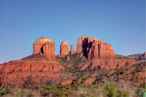
Cathedral Rock Trail
Distance: 1.2 miles round trip | Difficulty: Moderate–Strenuous | Elevation Gain: 652 feet
Cathedral Rock is the hike most people picture when they think of Sedona. The trail is short, but the last quarter mile involves genuine rock scrambling — using your hands to pull yourself up steep sandstone faces.
Hikers who are comfortable on exposed terrain handle it without issue; those who are not comfortable with heights may want to stop before the final push, since the views are excellent long before you reach the top.
At the summit, you stand between two towering spires and look out across the opposite side of the valley. From a distance on the trail, you can also spot the Chapel of the Holy Cross, a church built directly into the red rock cliffs.
Cathedral Rock is also one of Sedona’s four widely recognized energy vortex sites — the other three being Bell Rock, Boynton Canyon, and Airport Mesa. The area draws meditators and spiritual visitors alongside hikers.
Parking is genuinely difficult. The trailhead on Back O’ Beyond Road has two small lots that together accommodate roughly 45 cars, and they routinely fill by 6:30–7 AM.
Important: From Thursday through Sunday, year-round, the road to this trailhead is closed to private vehicles — the only access during shuttle hours is via the free Sedona Shuttle (7 AM–5:30 PM). On Monday through Wednesday, private parking is allowed but still extremely competitive.
Alternatives include starting from the Baldwin Trailhead on Verde Valley School Road (adds approximately 3 flat miles), or connecting via the Templeton Trail from the Bell Rock area (adds approximately 5 flat miles). Sunset is considered the best time for photography here.
Devil’s Bridge
Distance: 3.9–4.2 miles round trip | Difficulty: Moderate | Elevation Gain: ~564 feet
Devil’s Bridge is the most famous hike in Sedona, and it earns the title. The trail leads to the largest natural sandstone arch in the Sedona area — a formation created over millennia by wind erosion carving through the rock.
Hikers can walk across the top of the arch, and the drop on either side makes for a dramatic photograph.
The most popular starting point is Mescal Trailhead, which connects via the Mescal and Chuck Wagon trails to the Devil’s Bridge trail.
This route is slightly longer but more scenic than starting from the Devil’s Bridge trailhead directly (which requires a high-clearance vehicle for the dirt road).
The trail is moderate throughout, with the steepest and most technical section arriving just before the arch itself — a half-mile climb involving rocky scrambling.
Crowds are a real factor here. Even at 6:30 AM, the parking lot can be filling. Lines to take a photo on the arch form early and grow quickly.
The trailhead parking lot has roughly 40 spots; street parking begins about a quarter mile back on Boynton Pass Road. Parking requirements can change seasonally, so checking current signage before arrival is recommended.
Boynton Canyon Trail
Boynton Canyon is widely considered one of the most beautiful trails in Sedona from start to finish. The drive in on Dry Creek Road alone offers impressive red rock scenery.
The trail itself begins in open desert and transitions into a shaded canyon, where towering sandstone walls rise on both sides and the trail remains mostly flat.
Near the beginning, you pass a recognized vortex site — look for a short side path leading up to a prominent rock. Wildlife sightings here are common, including javelina along the road and butterflies throughout the trail.
At the far end of the canyon, a steep final climb leads to an elevated viewpoint looking back down the canyon. The biggest draw for many hikers is a hidden subway cave — a long, cathedral-like alcove carved into the canyon wall that resembles a subway platform in its proportions.
Finding it requires leaving the main trail at a specific, unmarked point. Detailed directions are available in dedicated posts about this trail. Parking at the Boynton Canyon Trailhead is frequently full; street parking along the road is permitted in certain stretches.
Distance: 6–7.2 miles round trip
Difficulty: Moderate
Elevation Gain: Gradual
Long Canyon Trail → Birthing Cave
Distance: 1.9–2 miles round trip | Difficulty: Moderate | Elevation Gain: ~240 feet
The Birthing Cave is a large, curved sandstone alcove set into a cliff face, named for its striking anatomical resemblance to the female form. A local legend suggests it may have been associated with childbirth, though no confirmed historical evidence supports that claim.
The trail from Long Canyon Trailhead is flat for most of its length, with a steep final scramble up loose, sandy rock to reach the cave entrance. Cacti border the climb, so careful footing matters. Inside, the cave opens to a broad view of the valley and red rock formations beyond.
A wide-angle lens is helpful for photography, and a friend is more useful than a tripod given the sloped rock floor. A key navigation note: about 0.6 miles in, a log marks an unmarked split in the trail — turn left here to reach the cave. The AllTrails map is accurate; just watch for this fork.
Roadside parking at Long Canyon Trailhead is limited. Mescal Trailhead is a reliable alternative and puts you close to Devil’s Bridge as well if you want to combine the two in a single outing.
Challenging Hikes in Sedona
Bear Mountain
Distance: 4.6–5 miles out-and-back | Difficulty: Strenuous | Elevation Gain: ~2,000 feet
Bear Mountain holds a strong claim to the best views of any trail in Sedona. The trade-off is earning them. The hike is almost entirely uphill on the way out, with multiple false summits before the actual top. One section involves a brief scramble requiring both hands.
The terrain on flatter sections is slickrock — smooth, gently sloping stone that demands careful footing. There is no shade on this trail, which makes it poorly suited to summer afternoons.
At the summit, the landscape opens into a full, sweeping panorama over Sedona and the surrounding canyon country — a perspective that makes the rest of the popular trails look small.
The parking lot is shared with Doe Mountain and can fill, but is generally not as competitive as the trailheads closer to town.
Wilson Mountain
Distance: 11.5 miles out-and-back | Difficulty: Strenuous | Elevation Gain: Substantial
Wilson Mountain is Sedona’s longest major day hike and rewards those who complete it with two distinct summit overlooks. The Sedona Overlook faces south over the town, where all the familiar formations shrink to miniature scale below.
The North Canyon Overlook faces north toward Flagstaff and Humphreys Peak. For most walkers, the Sedona Overlook is the more beautiful of the two.
The trail begins in open desert before entering forested terrain, crossing a wildflower-covered ridgeline, and arriving at a saddle that feels like the summit but is not — there are still a couple of miles to go.
Wildlife is more common here than on lower trails; rattlesnakes have been reported on the North Wilson route, and coyotes are occasionally heard near the summit.
The parking lot near Midgley Bridge is small and fills quickly. A second trailhead for the North Wilson route has its own smaller lot and is typically less busy.
West Fork Trail
Distance: 6.5–6.6 miles out-and-back | Difficulty: Easy–Moderate | Elevation Gain: Minimal
West Fork Trail is technically flat and not strenuous, but it earns its own section because of its unique character. Located in Oak Creek Canyon, the trail involves 13 creek crossings on stepping stones and leads through a canopy of trees along a lush, shaded corridor.
The canyon walls rise on both sides as the trail narrows toward a section some call the “narrows”, where wading becomes necessary to continue further.
It is one of the best summer hiking options in Sedona because of the shade and creek access. However, it is not advisable in late winter when snowmelt causes creek levels to rise rapidly — crossings that were manageable on the way can become impassable on the return.
An abandoned homestead near the trailhead belonged to a local legend named Jesse Jefferson “Bear” Howard.
Important note: West Fork Trail charges $12 for day use and does not accept the standard Red Rock Pass. Pass acceptance can change, so checking the current entry policy before arrival is recommended.
Payment is made at a staffed station, not a machine. Arrive early — the parking lot is large but the trail is extremely popular.
Doe Mountain Trail
Doe Mountain offers a disproportionate reward for relatively little effort. The trail climbs steeply via switchbacks to the top of a flat mesa, where the views open in multiple directions.
Looking one way you see the red rock valley toward Devil’s Bridge; rotate and you see the town of Sedona spread out in the other direction.
At sunrise, hot air balloons drift over the valley and are clearly visible from the mesa top — one of the more memorable Sedona sights.
The trail is also notably less crowded than most others on this list. The parking lot is shared with Bear Mountain and is a reasonable size.
Distance: 1.5 miles round trip
Difficulty: Easy–Moderate
Elevation Gain: 492 feet
Choosing the Right Trail
| Trail | Distance | Difficulty | Best For |
| Bell Rock | 0.8–1.1 mi | Easy | Families, first-timers |
| Airport View Trail | 1.4 mi | Easy | Sunset views, vortex |
| Red Rock Crossing | ~0.5 mi | Easy | Photography, creek scenery |
| Amitabha Stupa Loop | 0.3 mi | Easy | Short walks, spiritual interest |
| Soldier’s Pass | 3–4.7 mi | Moderate | Caves, sinkholes, variety |
| Cathedral Rock | 1.2 mi | Moderate–Strenuous | Iconic views, scrambling |
| Devil’s Bridge | 3.9–4.2 mi | Moderate | Natural arch, photos |
| Boynton Canyon | 6–7.2 mi | Moderate | Shade, hidden cave, vortex |
| Birthing Cave | 1.9–2 mi | Moderate | Unique formation, short day |
| Bear Mountain | 4.6–5 mi | Strenuous | Best panoramic views |
| Wilson Mountain | 11.5 mi | Strenuous | Long day hike, summit |
| West Fork Trail | 6.5–6.6 mi | Easy–Moderate | Shade, creek, summer hiking |
| Doe Mountain | 1.5 mi | Easy–Moderate | Sunrise, balloons, mesa |
Sedona’s trails cover every kind of hiker — short walks for families, half-day moderate routes for those wanting solid scenery without serious exertion, and full-day climbs for those who want to earn their views.
The red rock landscape is consistent throughout, which means even the easier trails offer scenery that would be the highlight of hiking elsewhere.
Plan ahead for parking, start early on the popular routes, and carry more water than you think you need.
A travel content creator providing destination insights, practical advice, and travel inspiration for every journey.