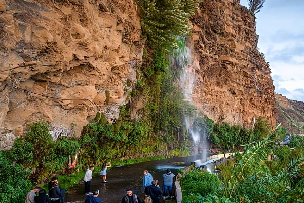
Few people think of Portugal as a waterfall country, but it has dozens of them — hidden in national parks, spilling off volcanic cliffs, and threading through ancient irrigation channels. The waterfalls in Portugal are spread across three regions: the mainland, Madeira, and the Azores. This guide covers each one with verified facts on location, height, trail access, and the best time to visit.
Why Portugal Has So Many Waterfalls
Mountains and rain are the main reasons why there are so many waterfalls in Portugal.
The northern mainland sits on granite and schist ranges that push past 1,000 meters, and rivers dropping off these heights carve ledges and valleys all the way to the coast.
Winters are wet, springs are strong, summers are dry — so most mainland waterfalls peak between March and May and fade by August. Madeira and the Azores work differently.
Both sit in the middle of the Atlantic, catching moisture year-round, and Madeira’s interior peaks cross 1,800 meters just a short distance from the shoreline. The water has to go down quickly because it has nowhere else to go.
One vocabulary note: Portuguese uses cascata for wider falls and salto for narrower, more vertical ones. Both appear on trail signs throughout the country.
Mainland Portugal
Cascata da Frecha da Mizarela
Set within the UNESCO Global Geopark of Arouca in the Aveiro District, Cascata da Frecha da Mizarela is the tallest waterfall on mainland Portugal, dropping approximately 75 meters over granite and schist rock on the Freita Mountain Range at around 910 meters altitude.
At the base, a laurel forest has established itself in the permanent spray zone, giving the surroundings a distinctly green, enclosed character.
The entry road starts near the exit from the village of Rossas on road N224 that goes to Saril. Several other significant waterfalls exist within the same geopark, including the Aguieiras waterfall approximately 40 kilometers away.
Fisgas do Ermelo
Inside Parque Natural do Alvão in the Trás-os-Montes region, the Olo River does not fall in a single dramatic drop — instead, it descends through a series of tiered horsetail cascades across a total elevation change of roughly 200 meters.
The water moves from pool to pool through a landscape of grey and green slate, surrounded by the jagged ridges of the Alvão mountain range.
The result is less a single waterfall and more a continuous staircase of water that stretches down an entire mountainside. It is widely considered one of the most dramatic waterfall systems on mainland Portugal.
Cascata do Arado
Portugal has only one national park — Peneda-Gerês, in the far northwest near the Spanish border — and Cascata do Arado sits near its heart.
The Rio Arado cuts through a sequence of granite corridors, producing cascades and clear green pools before reaching a lake at the base.
The waterfall sits at around 900 meters altitude, roughly 3 kilometers from the village of Ermida. The final kilometer of road leading to the trailhead is unpaved, and reaching the viewpoint requires climbing stone steps.
The area surrounding the falls also contains Cascata da Rajada, Cascata da Laja, Cascata de Leonte, and Cascata de Fecha de Barjas — all within reasonable walking distance.
Cascata da Portela do Homem
Known alternatively as São Miguel Waterfall, this cascade is formed by the Homem River just south of the Portela do Homem border crossing in the Braga District.
Rather than a clean single drop, the river descends a natural rock staircase in a chain of smaller cascades, surrounded by ferns and overhanging trees.
The trees and plants around the water form a natural cover that shades the area for most of the day.
Cascata da Água d’Alta
Where the Ribeira de Lamoso river reaches the edge of the plateau and drops into the Douro Valley, it creates Cascata da Água d’Alta — a fall of approximately 30 to 35 meters onto the rocks below.
The waterfall sits within the International Douro Natural Park, a protected zone on Portugal’s northeastern border with Spain.
The park is notable for its biodiversity: birds of prey, deer, and wild boar are regularly documented here, alongside several rare plant species.
The combination of dramatic river valley landscape and active wildlife makes this one of the more compelling waterfall locations on the mainland.
Cascata da Fraga da Pena
Located within the Protected Area of Serra do Açor in the Coimbra District, this horsetail waterfall drops roughly 20 meters down a face of moss-covered rock.
The water disperses as it falls, creating a fine mist that settles on the vegetation nearby. The surrounding area is part of a broader protected landscape in the central interior highlands.
Cascata da Cabreia
In the Aveiro District, the fast-flowing Mau River drops over a rocky ledge surrounded by dense forest, producing what is locally called Cascata da Cabreia or Cabreia Waterfall.
The forest coverage around the falls is thick enough that the waterfall remains partially shaded throughout the day.
Poco do Inferno
The name translates to Hell’s Pool, which sounds more dramatic than the waterfall itself warrants. One of three cascades formed by the Asseca stream in the Serra da Estrela area, Poco do Inferno drops into a natural pool below.
A local legend explains the name: a carriage reportedly fell into the pool centuries ago and was never recovered. The legend spread, and the name stuck.
Madeira
Madeira’s waterfalls are inseparable from the island’s levada network — a system of narrow stone-lined channels built between the 15th and 20th centuries to carry water from the wet northern mountains to the drier agricultural south.
Today, more than 2,000 kilometers of levada paths double as hiking trails, many of which pass directly beside or behind waterfalls.
This is what makes waterfall hiking in Madeira structurally different from the mainland: the trails are mostly flat, following the water channels rather than climbing above them, and the waterfalls appear without warning as the path curves around a cliff face.
Cascata dos Anjos
Near the town of Ponta do Sol on Madeira’s southern coast, a waterfall falls directly onto a public road. Drivers pass underneath it after exiting a tunnel.
There is no trail required — the waterfall is simply there, on the road, falling on whatever passes beneath it.
The volume varies considerably with rainfall, but even in drier months a steady stream comes off the cliff face. It is one of the more unusual waterfall encounters in Portugal.
Levada das 25 Fontes
The name refers to 25 distinct natural springs that converge around a small lake — Lagoa das 25 Fontes — deep in the Rabaçal valley.
The trail from the Rabaçal car park covers roughly 3 kilometers of descending path through the Laurissilva forest, a UNESCO World Heritage Site.
The springs emerge from the rock face surrounding the lake, creating a semicircle of water streams around the pool.
Rainbow trout have established themselves in the lake and are clearly visible from the bank. The trail back involves significant uphill walking and staircase sections.
By mid-morning, the trail becomes noticeably crowded; early start is strongly advisable.
Risco Waterfall
On the same trail system as the 25 Fontes, a short detour from the main path leads to Risco Waterfall, which stands over 100 meters high.
From the viewpoint, the base of the falls is not visible — the dense tree cover at the bottom of the valley obscures it entirely.
The official trail designation is PR 6.1 (Levada do Risco), which runs through the Laurissilva forest within a UNESCO World Heritage zone. Most hikers combine both Risco and 25 Fontes in a single outing.
Véu de Noiva (Bridal Veil Waterfall)
On the northern coastline of Madeira, Véu de Noiva falls from the cliffs directly into the Atlantic Ocean.
The road leading close to the base is unmaintained and unsafe, so the waterfall is viewed from a designated roadside viewpoint where parking is available.
The shape of the falling water — narrow at the top, spreading as it falls — is the origin of the bridal veil comparison.
Levada Nova Waterfall
Part of the Levada do Moinho – Levada Nova walking route, this waterfall is reached after passing through a rock tunnel. The tunnel requires a headlamp or phone flashlight to navigate safely.
Once through, the path opens directly in front of the waterfall. The full route is 5 kilometers each way and runs mostly flat along agricultural terraces, with open views toward the sea and the Paul da Serra plateau.
Caldeirão Verde (Green Cauldron)
At 100 meters high, Caldeirão Verde sits at the end of one of Madeira’s longer waterfall trails — 6 kilometers one way, with multiple rock tunnels along the route, each requiring a light source.
The trailhead parking area charges a fee. Tunnel conditions vary significantly with weather: after heavy rain, walls drip and the path becomes slick. Bringing snacks and sufficient water is necessary given the overall walking distance.
Cascata da Garganta Funda
Located in the Calheta area in western Madeira, Garganta Funda reaches approximately 140 meters in height, placing it among the tallest waterfalls on the island.
A short walk leads to the viewing point, making it one of the more accessible tall waterfalls in Madeira without requiring a full-day hike.
Waterfall on Levada do Rei
Within the UNESCO-protected Madeira Natural Park in the São Jorge municipality, this waterfall sits right beside the narrow levada path, close enough that walkers pass within arm’s reach of the falling water.
The surrounding laurel forest creates a dense canopy. Water volume is markedly seasonal: in summer, the falls carry little water; from winter through spring, the volume increases substantially and a rain jacket is a practical necessity.
The Azores
The Azores is a group of nine volcanic islands scattered across the mid-Atlantic, roughly 1,500 kilometers west of Lisbon. The islands are geologically young and seismically active, with steep terrain and persistent rainfall. Several islands contain notable waterfalls, the most documented of which are on São Miguel and Flores.
Cascata da Ribeira Quente
Cascata da Ribeira Quente is located between two road tunnels on road EN2-2A, between Furnas and the village of Ribeira Quente on São Miguel.
The waterfall is between 25 and 45 meters high, according to different sources. The government tourism organization for the Azores says it’s about 25 meters high, while independent visitors say it’s up to 45 meters high.
The water originates from geothermal springs inside the island, and high iron content in the water gives the surrounding rock a distinctive reddish-orange color.
To reach it, park outside the first tunnel from the Furnas direction and walk through — the waterfall becomes visible between the two tunnels. Because the tunnel is narrow and shared with cars, people going through it need to be careful.
Salto do Rosal
Salto do Rosal drops approximately 30 meters inside the forested grounds of Mata-Jardim José do Canto near Furnas Lake. The garden charges an entry fee to access the grounds.
The trail to the waterfall covers roughly 2 miles round-trip and passes through dense laurel forest, an old Gothic chapel, and one of the largest collections of ancient camellias in the Azores.
Note: As of March 2026, the direct access path to the waterfall is temporarily closed due to a landslide, though other sections of the trail remain open.
Cascata Salto do Cabrito
Framed by tall volcanic cliffs on São Miguel, Salto do Cabrito drops an estimated 30 to 40 meters, though its full height is difficult to measure precisely because parts of the cascade are hidden in rock crevices. It is one of several cascades in the area.
Poço do Bacalhau — Flores Island
Poço do Bacalhau stands 90 meters high — confirmed by Wikipedia and multiple official Azores tourism sources — and falls into a natural pool near the village of Fajã Grande, the westernmost settlement in Europe.
The pool is suitable for swimming. The name translates to “Cod Pool,” most likely referring to a cod-shaped rock at the base of the falls. A 600-meter flat path leads from the edge of the village to the base of the waterfall.
In summer months, the flow reduces significantly; in winter and spring it is at full force. Freshwater eels are present in the pool below the falls.
When Water Levels Are Highest
On the mainland, the window between March and May brings peak water levels combined with manageable temperatures for hiking. By July and August, several smaller waterfalls reduce to a trickle or stop flowing entirely.
Planning a waterfall visit in autumn or early winter on the mainland carries the risk of variable trail conditions, but water volumes will already be rising. In Madeira and the Azores, there is no dry season in the same sense.
Waterfalls run year-round, though individual trail conditions — particularly tunnel sections in Madeira — become wetter and slicker in heavy rain periods between November and February.
Trail and Safety Notes
Levada trails in Madeira run along narrow ledges in places, and several sections require some degree of comfort with exposed heights.
The Levada Nova route in particular has stretches where the path is narrow and the drop to one side is significant. In Madeira, there are a lot of rock tunnels on waterfall walks. You need to bring a light with you.
Footwear with solid grip is appropriate for all waterfall trails in Portugal. After rainfall, basalt and granite surfaces become extremely slick.
Most major waterfall trailheads have parking areas, though sites like the Rabaçal valley on Madeira fill quickly and early arrival matters.
You can get to most waterfalls on the island and in Madeira for free. Some locations in the Azores, particularly those within botanical gardens or private parks, charge entry fees.
A travel content creator providing destination insights, practical advice, and travel inspiration for every journey.