The waterfalls near Portland are among the most accessible and scenic in the entire United States.
Within a short drive from the city, the Columbia River Gorge alone contains over 90 major cascades along its Oregon side.
Add to that the waterfalls tucked inside Mount Hood National Forest and Silver Falls State Park, and you have enough waterfall hikes to fill an entire season of weekend trips.
This guide covers the most notable ones — what they look like, how to reach them, what passes you need, and when to go.
All distances, heights, trail lengths, and permit details in this guide are verified from official sources including the U.S. Forest Service, Oregon State Parks, and Travel Portland.
Road conditions change seasonally, so always check current alerts before heading out.
Road Notice (2025–2026): A section of the Historic Columbia River Highway east of Multnomah Falls is closed through spring 2026 for road improvements. All waterfalls in this guide remain accessible via Interstate 84. Check ODOT TripCheck for live updates.
Columbia River Gorge Waterfalls
The Historic Columbia River Highway, which is also called U.S. Route 30 — runs along the Oregon side of the gorge and gives access to the highest concentration of waterfalls near Portland.
Most of the falls listed below are within a 40 to 55 minute drive from the city and can be combined into a single day trip.
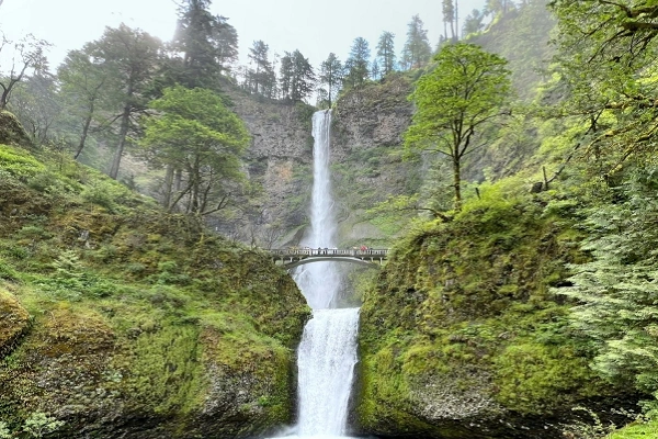
Multnomah Falls
It is 620 feet high, making Multnomah Falls the biggest waterfall in Oregon. It drops in two tiers over a sheer basalt cliff in the Columbia Gorge, with the historic Benson Bridge — built in 1914 — spanning the lower section.
The falls are fully visible from the parking area and visitor center, which means no hiking is required to see them. For a closer look, a paved 0.2-mile path leads to the bridge.
The full Multnomah Falls Trail is 2.4 miles round trip with 813 feet of elevation gain, taking hikers to the top of the falls.
Drive from Portland: 30 minutes
Height: 620 feet Trail: 0.2 miles to bridge | 1.1 miles to top | 2.4 miles full round trip
Parking pass: Timed-entry permit required May 24 – Sept 2, between 9 AM and 6 PM. Cost: $2. Reserve at recreation.gov up to two weeks in advance.
Dogs: Allowed on leash
Facilities: Restrooms, lodge, food service, gift shop
To visit free of charge during peak season, arrive before 9 AM or after 6 PM — no permit is checked outside those hours. Outside of the May–September window, no permit is needed at any time.
Latourell Falls
Latourell Falls is the closest waterfall to Portland in the Columbia Gorge, located inside Guy W. Talbot State Park off Exit 28 on Interstate 84.
The falls drop freely 220 feet over a dramatic columnar basalt formation — one of the most visually distinct geological features in the gorge.
A short paved walk from the parking lot reaches the base. An additional 0.1-mile unpaved descent leads closer to the plunge pool.
The full 2.1-mile loop trail climbs to Upper Latourell Falls and offers views of the Columbia River from the ridge.
Drive from Portland: 35–40 minutes
Height: 220 feet
Trail: Short walk to base | 2.1-mile loop to upper falls (639 ft elevation gain)
Parking pass: None required
Dogs: Allowed on leash
Wahkeena Falls
Wahkeena Falls sits 242 feet tall and cascades in multiple tiers through a lush forest of ferns, Douglas fir, and moss-covered rocks.
The trailhead is located close to Multnomah Falls, and a 0.25-mile steep but paved path leads directly to the base of the falls.
Standing at the bottom, the cold mist coming off the water is strong enough to feel from several feet away.
For those wanting to continue, the trail extends another mile to Fairy Falls — sometimes called Ghost Falls when sunlight hits the water at certain angles.
The round trip to Fairy Falls is approximately 3 miles. The terrain past Wahkeena becomes rocky and muddy in sections.
Bridal Veil Falls
Bridal Veil Falls drops in two separate cascades that together resemble the layered tiers of a wedding veil.
The waterfall is 118 feet tall and sits inside Bridal Veil Falls State Scenic Viewpoint, located 27 miles east of Portland just off Interstate 84. From the same parking lot, you can start two short walks.
The lower trail is 0.5 miles round trip on a paved, accessible path ending at a viewing platform directly in front of the falls.
A second upper trail — the Overlook Trail — is also 0.5 miles and leads to a panoramic view of the Columbia River Gorge, Beacon Rock, and Hamilton Mountain.
Drive from Portland: 30–35 minutes
Height: 118 feet
Trail: 0.5 miles to falls | 0.5 miles to overlook — both easy, paved
Parking pass: None required
Dogs: Allowed on leash
Horsetail Falls and Ponytail Falls
Horsetail Falls is 176 feet tall and sits directly beside the Historic Columbia River Highway, making it one of the most visible and easily reached waterfalls in the gorge.
The parking area is directly across from the falls, and no hiking is needed to see it.
Ponytail Falls is 0.3 miles up the trail from the Horsetail parking lot. The water falls from a crevice in the rock above, and the trail passes directly behind the falls through a natural rock alcove.
This behind-the-falls experience makes Ponytail one of the most distinctive stops in the gorge.
The 0.6-mile round trip hike involves some steep and rocky sections. Continuing on the 2.6-mile loop trail also brings hikers past views of Oneonta Gorge.
Elowah Falls
Elowah Falls drops 213 feet into a wide basalt amphitheater coated in deep green lichen and hanging moss.
The 1.5-mile round trip trail passes through a forest that was partially burned in a previous fire, and the contrast between the charred trees and the lush, dripping alcove at the falls is striking.
Because the trail requires a short hike, Elowah sees far fewer visitors than most other waterfalls in the gorge.
An optional extension adds Upper McCord Creek Falls to the route for those wanting a longer outing.
Drive from Portland: 40–50 minutes
Height: 213 feet
Trail: 1.5 miles round trip, rated moderate
Parking pass: None required
Dogs: Allowed on leash | No restrooms at this location
Wahclella Falls
Wahclella Falls sits at the end of a 1.9-mile round trip trail along Tanner Creek.
The path crosses the creek on wooden bridges several times and passes a number of smaller cascades before arriving at the main falls.
The canyon walls narrow toward the end of the trail, and the falls emerge in a tight, enclosed space that amplifies the sound of the water.
Drive from Portland: 50 minutes
Trail: 1.9 miles round trip | 223 ft elevation gain | Moderate
Parking pass: Northwest Forest Pass or $5 cash at trailhead
Dogs: Allowed on leash | Outhouse available
Hole-in-the-Wall Falls
Hole-in-the-Wall Falls is located inside Starvation Creek State Park and gets its name from the way the water exits through an opening in the rock face rather than dropping over the top.
The trail is fully paved and rated easy, making it one of the most accessible waterfall hikes in the gorge. Cabin Creek Falls appears along the same trail.
The path runs close to the highway and road noise is noticeable for much of the walk.
Drive from Portland: 1 hour
Trail: 2.1 miles round trip | 200 ft elevation gain | Easy | Paved
Parking pass: None required
Dogs: Allowed on leash | Restrooms available
Eagle Creek Trail Waterfalls
The Eagle Creek Trail is one of the most well-known hiking trails in Oregon.
It runs through a deep canyon lined with towering basalt walls and passes more than 20 waterfalls over its 6.5-mile length to Tunnel Falls.
The trail was affected by the 2017 Eagle Creek Fire but has since partially reopened. At the entrance, you’ll need a Northwest Forest Pass.
Punch Bowl Falls
About two miles into the Eagle Creek Trail, you’ll come to Punch Bowl Falls. The falls drop into a wide, bowl-shaped pool of clear green water surrounded by canyon walls.
As a result of the 2017 fire, a large log jam now blocks the original entrance to the pool, and reaching the water requires navigating over the debris.
Cliff diving at this location is prohibited and subject to a $300 fine.
Drive from Portland: 45 minutes to Eagle Creek Trailhead
Trail to Punch Bowl: 4.2 miles round trip | Moderate
Parking pass: Northwest Forest Pass or $5 at trailhead
Tunnel Falls
Tunnel Falls is located at the far end of the Eagle Creek Trail, approximately 6.5 miles from the trailhead.
The waterfall drops 160 feet, and the trail passes directly behind it through a man-made tunnel blasted into the rock cliff.
The hike involves sections of exposed trail along cliff edges with safety cables installed for support. The full round trip is 13 miles with 2,070 feet of elevation gain.
Full round trip: 13 miles | 2,070 ft elevation gain | Moderate-Strenuous ,
Note: Exposed cliff sections — not recommended for those with a serious fear of heights
Silver Falls State Park
Trail of Ten Falls
Silver Falls State Park is Oregon’s largest state park at over 9,000 acres and sits in the Cascade Mountain foothills about 60 miles south of Portland.
Its Trail of Ten Falls is an 8.7-mile loop that passes exactly ten waterfalls, four of which can be walked behind.
The most photographed waterfall on the trail is South Falls, which drops 177 feet and allows hikers to pass under its curtain on a trail carved into the rock behind it.
The trail is rated moderate, and the elevation gain of around 1,151 feet is spread across the full loop.
Shortcuts exist that allow hikers to skip some falls and shorten the route. The park has campgrounds, picnic areas, restrooms, a cafe, and a historic lodge that is open year-round.
Mount Hood Waterfalls
Ramona Falls
Ramona Falls is located inside Mount Hood National Forest, 57 miles from Portland. The waterfall fans out 120 feet across a wide face of moss-covered basalt rock, spreading horizontally as it descends.
The 7-mile trail follows the Sandy River through dense old-growth forest and also runs along a section of the Pacific Crest Trail.
The original wooden footbridge over the Sandy River washed out in a flood, so hikers now cross on logs — waterproof boots are important.
Drive from Portland: 1 hour 10 minutes
Height: 120 feet Trail: 7 miles round trip | Moderate
Parking pass: Northwest Forest Pass | Wilderness permit required mid-May to mid-October
Dogs: Allowed on leash
Tamanawas Falls
Tamanawas Falls sits on the eastern slope of Mount Hood and drops 110 feet from the lip of a lava cliff into a cold pool below.
The 3.4-mile round trip trail follows Cold Spring Creek for most of its length through conifer forest.
Because the hike is slightly longer than the gorge trails, this waterfall tends to be less crowded.
Drive from Portland: 1 hour 45 minutes
Height: 110 feet
Trail: 3.4 miles round trip | Moderate
Parking pass: Northwest Forest Pass or $5 at trailhead
Dogs: Allowed on leash
Willamette Falls
Willamette Falls is located in Oregon City, 20 miles southeast of Portland, making it the closest major waterfall to the city that requires no hiking at all.
The falls stretch across the Willamette River and are visible from several drive-up viewpoints.
The McLoughlin Promenade offers a view from the bluff above downtown Oregon City.
A pullout on Highway 99E gives a direct roadside view. The falls are also visible from Interstate 205 with Mount Hood visible in the background on clear days.
Guided boat tours are available for a water-level perspective.
Drive from Portland: 20 minutes southeast
Hiking required: None — multiple drive-up and walk-up viewpoints available
Parking pass: None required
Best Time to Visit
The waterfalls near Portland can be visited in any season, but water volume and trail conditions vary throughout the year.
Spring (March to May): The highest water flow of the year due to snowmelt and spring rainfall. Late April is the period most commonly cited for peak conditions.
The Waterfall Corridor timed-entry permit does not start until late May, so visiting in April or early May means free, open access with no reservation needed.
Summer (June to August): The warmest and driest conditions, but also the busiest. Timed-entry permits for the Waterfall Corridor are required between late May and early September.
Book permits as early as possible, especially for weekends. Water flow is noticeably lower than in spring.
Fall (September to November): Crowds decrease after Labor Day. Rainfall returns and water volume increases. Autumn foliage adds visual interest to many trails, particularly on the Eagle Creek Trail and around Silver Falls.
Winter (December to February): The gorge in winter is nearly empty of visitors. Multnomah Falls occasionally partially freezes, creating a different kind of spectacle.
Some longer trails may have icy sections — check trail reports before setting out. Shorter trails like Latourell and Bridal Veil are generally accessible year-round.
Permits and Passes
Timed-entry permit ($2): Required for the Columbia River Gorge Waterfall Corridor — covering Multnomah Falls, Wahkeena Falls, and Horsetail Falls — from approximately May 24 to September 2, between 9 AM and 6 PM.
Reserve at recreation.gov up to two weeks in advance. Outside those dates and hours, no permit is needed.
Northwest Forest Pass ($5/day or annual): Required at Wahclella Falls, Eagle Creek Trailhead, Ramona Falls, and Tamanawas Falls. Can be purchased at the trailhead (cash only at some locations) or in advance online.
Silver Falls day-use fee ($5): Paid at the park entrance or trailhead booths. Cash or card accepted.
Ramona Falls wilderness permit: Required in addition to the Northwest Forest Pass from mid-May to mid-October.
Parking Tips
Parking at all Columbia Gorge trailheads fills quickly, especially on weekends and holidays between May and September.
- Arrive before 9 AM on weekdays and before 8 AM on weekends during peak season.
- Multnomah Falls has the most parking and a bus service, which makes it a good place to stay if you want to walk to other nearby falls.
- If the Wahkeena lot is full, park at Multnomah and take the 0.5-mile connecting trail.
- You won’t see as many people at Elowah Falls, Wahclella Falls, and Hole-in-the-Wall Falls because their lots are smaller.
- For Silver Falls State Park, arrive early on spring weekends — the park is popular with families and day-trippers from Portland and Salem.
What to Bring
Waterproof footwear: Trails in the gorge are frequently wet and muddy, even in summer. Waterproof hiking shoes or boots prevent slipping and keep feet dry near the plunge pools.
Rain jacket: Mist from larger falls like Multnomah and Wahkeena can soak light clothing within a few minutes. A waterproof shell layer is worth carrying even on clear days.
Microspikes: Useful from November through March on trails with steep sections. Not needed for short, low-elevation walks like Bridal Veil or Horsetail.
Water and food: Multnomah Falls is the only gorge location with food service on site. All other trailheads have no facilities nearby.
Trail conditions app: Check AllTrails or the U.S. Forest Service website for current conditions and any recent trail closures before setting out.
Travelers spending more time in the region can also explore things to do in Seattle, which sits just three hours north of Portland. Those looking for a more remote wilderness experience may also find Patagonia adventure tours worth exploring.

A travel writer sharing informative guides, tips, and itineraries to help travelers explore the world smarter.